
The Legends of My Mountain Valley
Preface:
This work paints some of the geologic and cultural histories of the beautiful Kamas Valley, as first told through the soul and eye of a municipal deep-water well, constructed in 1998. It is one I spent countless hours planning and developing when I was the Mayor of Oakley City. Written originally to promote the purity and antiquity of its water, this new story extends to a more protracted chronicle and audience. The shapes of all beauty sheltered in this valley are found indirectly in the forces and natures of its living mountains and passionate water resources.
The uncouth, wrenching red tower of well-drilling equipment has been removed from its site—and after a long month of thunderous boring, silence finally falls over the land. Nearly two thousand feet deep, it has pierced many layers of the subterranean rocks of the ancients. Now, all that remains are the lonely, worn vestiges of dried, cracked mud and shattered rock cuttings, lifted to the surface to catch their first flicker of sunlight in hundreds of millions of years.
In the center of the drilling pad, hewn out of the side of Seymour Canyon, rests a large vertical pipe (also painted red), jutting from the ground, about four feet tall. This stub is where the massive, torturous drill planted its drive—a sharpened stinger—deep into the timeworn—unforgiving earth.
While I sit atop this contraption, water pours from a port on its side, splaying across flats, then down a canyon below. It splits into long, trembling fingers of cold, emptying its deep life over dry, scorching rocks and sagebrush. Like a syringe drawing from the earth, it bleeds out countless drinks of history, piece by piece, while nourishing the legends and futures of our long-drawn-out mountain valley.
By tapping into the chill of Earth's deep, teeming aquifers, we discovered an often-forgotten story of its hard-fought journey through darker times, as well as its legacy that we all tap. And as so often revealed—the brutality of Earth's formation eventually relents in the peacefulness of its clear healing waters.
Far beneath me, flowing upward through thousands of feet of rock and rusting well casing, I contemplate this chronicle against a looming mountain that props up our sky. Peering down the dark, flowing borehole, I sense that every drop of water carries the relics and artifacts of some past. A legend filled with many cold springs—too brutal to know or even understand. I deliberately ponder these hidden spirits—their essences leaching from stony bones, feeding into our expansive, soothing valley below.
_______________
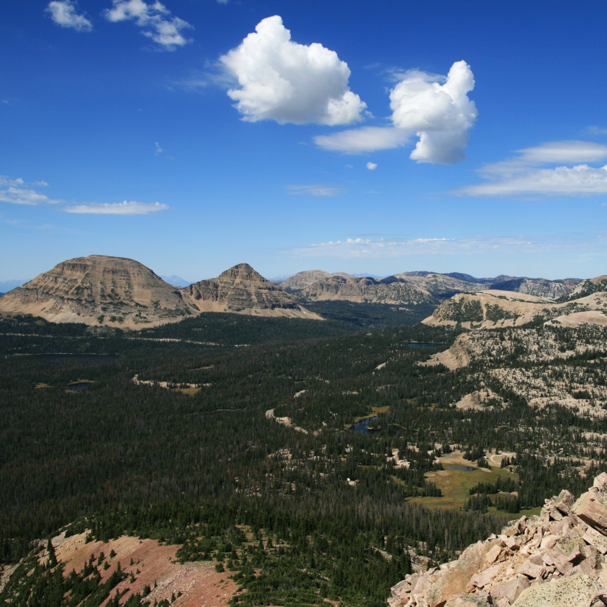
In this lucid daydream—I journey through Earth’s timely, watery bowels, voyaging far back, about one and a half billion years, to the valley's infancy and its tall eastern guardian—the gritty yet proven peaks of the high Uinta Mountains. A massif born, or more appropriately, recycled from its transient progenitors.
The Uinta Mountains, seemingly indefatigable, were reborn from the shattered remnants of another ancient range, the immense and forgotten Red Creek Mountains. Fragments still stand—scattered in pockets on its isolated eastern flanks, weathered and disembodied, near the Flaming Gorge Canyon of the mighty Green River. These remnants now expose some of Utah's oldest rocks.
Such a primordial and massive edifice, respirating, perspiring, and wearing for a billion years or so on its own. Yet its time was destined to be methodically and slowly eroded—carried away to a more profound nothingness, to patiently await its slow, quiescent reformation.
Under that setting, the Uinta Mountains we see today took shape in Earth's antediluvian past. First, within the warm wombs of a newly created trench, larger than the Grand Canyon (nearly 160 miles long by 50 miles wide), it was an abyss—of extraordinary dominance and capacity. Then—over the next billion years or so—this rift, known as the "Uinta Trough," gradually filled—burdening itself with shallow-water sediments and soups of ancient seas, and even stranger forms of life.
As its belly filled, a heaviness sank its goliath glob of sand to depths of over 25 thousand feet. The teeming primordial goo condensed, compacted, and cemented as it mustered some strength. Strangulated by heat expelled from deep, molten magmas that feverishly floated their shifting continental plates—these sandstone concretions underwent an immense metamorphosis, solidifying into case-hardened quartzites and slates. The entire Uinta rock formation slowly took shape. This era was known as the Precambrian period.
Fifty million years ago, the Pacific Ocean tectonic plate rammed into the North American plate, triggering a mountain-building event known as the "Laramide Orogeny." Like stacking blankets of earth, the long-dormant monolith of Uinta rock was thrust upward from its grave through compressive folding. Other mountains in the area—like the Wasatch Range—followed. Since its early infancy, it has become one of only two mountain ranges on the North American continent to form a unique yet stately east-west monument to time.
Over many ages, this ongoing upheaval and collision of plates formed numerous other thrust faults that surrounded this new and infantile Uinta range. Organic matter was trapped, folded, and smothered beneath its heaving slides and shifting sediments. Then, finally, everything began to congeal gently yet resolutely, forming the north and south Uinta slopes, with scattered coal fields and deeper oil and gas reservoirs.
Massive faulting also provided the seedlings, like a mysterious catalyst within voids of fractured rock—for the fluids of precious and strategic metals, heated by deep magmatic activity, to begin their gradual upward movement. These solutions would slowly be deposited and absorbed into the cooler—parent host rocks above. Such extraordinary condensations created a massive chain of birthing nurseries—for future veins of an expanding wealth in precious metals.
Nowhere was this more prevalent than in the north-south-aligned Wasatch Mountain range to the west. Here, the mountains sloped and collided with this east-west bulge, resulting in an intricate structure at their confluence and creating one of America's most magnificent silver and gold mining camps. In a future Park City—many a prospector would silently and covertly lay paper claims to any morsel of this filthy lucre they could extract from the deepest tentacle of a most jealous and reluctant earth.
Five million years ago—the last ice age began its final advance across our surreptitious Uinta range. Glacial erosion tore apart the steep citadels and massifs and gouged out irregular valleys. These newly honed watchmen—formed as glaciers ripped at all sides—stood afar off like impermeable sentinels, guarding the daggers of the main range and its hidden treasures buried securely within.
Like monster steel and wedging crowbars, the freezing and thawing waters repeatedly pried apart the rock's stress fractures. Peeling its outer layers, the rock slowly and deliberately heaped its rugged, dying debris, leaving it rounded into the many haystack mountains, giving a unique character to the eroded and present geography of this beautiful, matchless creation.
Reservoirs of ancient waters fell victim to the trappings of younger carbon-sequestering limestone foundations. Abutting and encircling this Uinta range, like rings of a tree, they contour outward in orderly displays of their various ages. These rings are where they secretly store their final sustenance of liquefied treasure.
Water labored onward, dissolving the weaker parts of these edifices, forming caverns and tendrils of natural pipes. It filled the depths of karst and countless fissures—buried thousands of feet below the surface. Pools that remain cold, pure, protected, ancient, and secret—stored in a long-dormant reserve to this day.
Lastly, on our geological scale, just ten thousand years ago, our ice age began to recede. Choked-off and dying glaciers left piles of stone and alluvium in their wake. Such glacial moraines formed basins for newly emerging lakes and life, providing the riparian wetlands to brood, nurture, and carefully cultivate the habitats of an ever-evolving consciousness. Again—life carved a deep foothold in these hardening pasts, adapting and thriving within its rugged destiny.
Nourished by water and sun, seedlings retook hold—grasslands and forests were reborn. Fertile soils spread, shaped by ongoing erosion from wind and water and by the breakdown of organic matter. Four thousand years ago, the Uinta’s finally began to resemble what we overlook and breathe today.
The nestling Kamas Valley also begins its final polish. As eroded cobble, alluvium, and nutrient-rich soils spread, carried by deluges and torrents from the Uinta arch, they deposit smooth, valuable layers. Westward-flowing rivers filter into aquifers and soak into shallow, spongy bogs. The valley becomes our current prairie of emerald abundance, extending into another era of nourishing glory.
With a geological scale so immense—humanity has perceived these treasures for only a recent microsecond and, most often, rather harshly. After the bear, the elk, the trout, the moose, and the beaver flourished, we entered our place in the mountain's narrow ecosystem, not only as a latecomer but as a short-timer.
Native Americans used only what they needed to survive and thrive in each season. They left little trace, and their footprints now lie faded in the wildernesses of time. Later, the Spanish forged trails north to seize and hide much of this newfound wealth, which those "ancient ones" once held sacred.
At the beginning of the nineteenth century, mountain men and trappers gathered at rendezvous on the north-slope plains of the Uinta Range. Here, the land was fertile and green, and wildlife roamed along cool streams where resources were most abundant. Fort Bridger became a much-needed oasis amid the enduring hardships faced by the West's new frontiersmen. Later, the Mormon Trail carried its pioneer sojourners through this same area, and their hunger was now fed by a plentiful highland of thankful provisions set upon a table of God's good grace.
Geologists named Powell, Hayden, and King surveyed and christened many of these 13,000-foot peaks, deliberately omitting the names of local politicians and dignitaries. Prospectors spoke of ancient, sacred mines—forever lost in the obscure hills and in the legends of dark mine shafts and tunnels. Myths and lies quickly took shape in the afterglow of smoke-drenched campfires.
In the 1860s, Park City was discovered and settled. Intertwined vaults of silver and gold, hidden for millennia, were discovered, exposed, and sacked by wily and ruthless treasure seekers. They transformed a fertile farming vale and pioneer retreat into the sprawl of one of the country's largest mining camps.
The transcontinental railroad spun its cold steel along a hack-tied path clinging to the Uinta's north slope. Such a giving and majestic mountain range continued to gaze over valleys filled with deeded homesteads, mining claims, and the notarized papers of modern commerce, stretching into Wyoming and across Utah.
Back into other newly exposed time machines, drilled into far deeper frontiers, engineers discovered the long-lost—the oil and gas reserves—pools trapped in the overthrust belt. Along with easily accessible coal, the mountains again fed the rough-and-tumble economies, further fueling the energy needs of its constant pioneer growth and the ardent industrial conveyor belts of western progress. The smoking hunger of its oily machines became insatiable.
Wyoming and the southern Uinta Basin rose from small outposts to boom towns overnight. Bolstered by the harvests of precious timber found in the verdant stands along the western ridge of the Uinta woods, Kamas Valley's prominence spread. As silver and oil fortunes continued to expand, the gentile populace arrived en masse, and newly planted townships offered opportunity, liquor, and other comforts for the tired and the opulent to spread and spend their money on.
All power, energy, and mammon aside, the most significant resource was yet to be fully developed and, like the others, would eventually be exploited: WATER. Our thirst for it remains insatiable, and westward expansion would have ceased without it as the primary tinder and fuel of growth. Likewise, the quilted agricultural vales blanketing Kamas Valley and Summit County would vanish without this ever-flowing lifeblood that feeds our meadows of commerce and peace.
Billions of dollars have been spent on this transparent necessity—relocating this water to distant realms beyond the confines of ridges, divides, and boundaries. And perched atop Bald Mountain Pass, one can peer afar—over the engraved veins of many headwaters. Much of the West's most significant watersheds are born here, and in one spot—four major river basins begin, then politely part their ways to feed a horde of mouths, including parched water lawyers...
Three drainages are exceptionally large and feed the Great Basin and Great Salt Lake: the Bear, the Provo, and the Weber. And one is a branch that extends from the Green—the Duchesne River. Drifting along the eastern Uinta flanks are many more that feed the broader trunk of the Green. And finally—the grandest of all, the Colorado River, which gapes open to consume them all in one monstrous swig of dammed wealth.
Over millions of years, the Weber, the Provo, and the smaller Beaver Creek sculpted our little mountain valley. Once called Rhoads Valley, it is now Kamas Valley. A dale formed within the higher elevations, where the spirits of many waters, past and present, lend us a portion of themselves. Much of Utah’s lifeblood, even extending to the Californian dynasty, gives its abundance to countless food tables across the United States. So much provision originates in this lonely yet often forgotten outpost or corner of a tall wildness we call—the Uinta!
___________________
Our presence in the present appears to be but a mere comma or sliver in nature's timeline. Yet the natural resources of the Uinta Mountains have fed our groaning appetites and built our demanding economies for times immeasurable. The immense influx of settlers, pushing westward, stopped to colonize the very contours that now encircle our present homes and estates. So many of us remain oblivious to the antiquities of the rocks, the soils, and the endless rivers of life on which we depend.
Clutched in time with our smartphones, our tiny mega cameras, and secured in the armor of our four-wheeled wonder machines, we view the passes of the ancients from paved viewpoints. In this short slice of time, we still have time to learn, to use, and not abuse all this natural variety. We can discover ways to shape our future well or dissolve any dream of lasting water, agriculture, or open space into the jaws of sprawling development. We must ask ourselves what we are willing to preserve—while it still can be preserved!
Our mountain's natural history sparks our diverse cultural history. We came to these mountains for wealth within; we stayed—sheltered by these massifs and their beauty without—and we continue to return to them—often to restore a portion of that life that patiently sustains us and that we impatiently long for in our deafening societies.
Let this then become our vision—not unlike the ancients, to use only a small yet essential portion of its natural generosity, which has provided for countless hidden forms of life. Without clear foresight, we can quickly succumb to the rage of the machines and engines of progress that will wrest away any peace a river and its partners, buried in the depths of green woods or ever verdant prairies, afford.
We can conserve and use wisely its water, food, soil, air, stone, timber, wealth, energy, grandeur, and lasting, peaceful shelter for our homes and families. But we must also pause and reflect… As we drink from the cold, deep wells of this long rock legacy, let us remember that the waters of the Uinta—while meandering through the endless meadows of time—were once carried on the backs of the ancient ones. It is a precious resource that should be developed and used responsibly—with quiet dignity and respect.
It is to taste the azure blues of the last great ice age. It is a source of antiquity, predating mankind's industrial, nuclear, and technological wizardry—which at times left behind many of its strange and dirty artifacts, like an ugly imprint on our planet. It is a pure relic—an ancient and forgotten remnant of an archaic, prehistoric, and wintry age—eons past, which we can profoundly enjoy today.
Drink this story in, in small, contemplative sips. This water is Life—experience it, protect it, and defend its verdant lands—at least as well as the earth has experienced and protected it from the blanketed shrouds of ancient times and olden stones—for millions of years…